TROPICAL CYCLONE WARNING STATEMENT Monday 4th September 2017
Hurricane Irma: Tropical Cyclone Warning Statement for the Leeward Islands
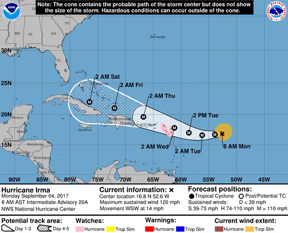
Antigua and Barbuda Meteorological Services 11:09 am ECT - Monday, September 4th, 2017 - A hurricane warning has been issued for the Leeward Islands to include Antigua and Barbuda, Montserrat, St. Kitts, Nevis and Anguilla. A hurricane watch is now in effect for the British Virgin Islands. A hurricane warning means that hurricane conditions are possible within the specified area within 24-36 hours. A hurricane watch means that hurricane conditions are possible within the specified area within 48 hours.
At 11:00 am ECT or 1500Z, the center of Hurricane Irma was located near latitude 16.8 north, longitude 53.3 west or about 560 miles east of the Leeward Islands.
Irma is moving toward the West-South West at 14 miles per hour. A turn towards the West is expected later today followed by a turn to the West North West late Tuesday. On the forecast track, the center of Irma will move closer to the Leeward Islands through Tuesday.
Maximum sustained winds have increased to 120 mph. Irma remains a Category 3 Hurricane on the Saffir-Simpson Scale. Additional strengthening is forecast through Tuesday night.
Hurricane force winds extend outward up to 35 miles from the center. Tropical Storm force winds extend up to 140 miles from the center. The estimated minimum central pressure is 944 mb or 27.88 inches.
Based upon the latest observation and analysis, Irma continues to show signs of organization, and further strengthening is possible before its path through the region. Also Irma is on a projected path that brings the Cyclone dangerously close to the Leeward Islands on Tuesday night. A turn to the West and subsequently west north west is forecast over the next 36 hours. Should there be any delay in this shift in motion, Irma could move directly over the islands. This means that stronger winds and heavier rainfall could be worse than previously anticipated for these islands.
Outer rainbands associated with the system could begin to affect the islands on late Tuesday with the Cyclone expected to pass at its closest point after midnight Tuesday. Rainfall totals of 3-6 inches are possible with the passage of Irma with maximum amounts of 10 inches. This could lead to flooding and residents in low lying areas should be prepared to move to higher ground.
Mariners should stay in port and seek safe anchorage. seas have started to deteriorate and will get worse over the next 24 - 48 hrs.
Preparations to protect life and property should be at an advanced stage, and all residents are urged to monitor the movement of Irma.
The next advisory will be at 5:00 pm ECT. Click here for more information.
Forecaster
Orvin Paige
Click here for all News and Specials for National Office of Disaster Services
| 


